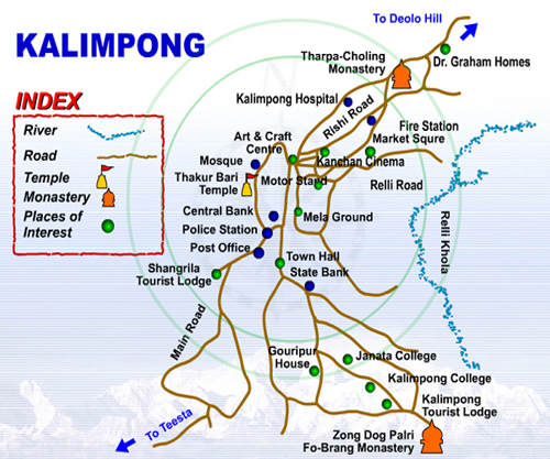
Kalimpong compares favorably with other hill stations in India. Infact it has advantags over most with its mild climate, good residential facilities, good schools and hospitals, clean surroundings, relaxed atmosphere and its glorious view of the mountain range. Kalimpong itself is the headquarters of the Sub-division of the same name. The town is not compact or concentrated but scattered along a ridge from an elevation of approximately 1150 mts. to 1450 mts. The bazaar is the seat of the saddle; to the north is the Delo hill and to the south the Durpin hill. The mighty Teesta River runs to the west of it, River Relli to the east. Kalimpong has come a long way since 1865 when it was a hamlet of 3- 4 families, to the hustling and bustling town that it is now. A town of almost 50,000 inhabitants - it is now one of the major town of the area.
KALIMPONG
Various scholars have given various meanings about the name-
Kalimpong. Mr. K.P. Tamsang, author of "The Unknown and Untold Reality
about the lepchas” opines that the original name is ’Kalenpung’ which in
Lepcha means_" Hillock of Assemblage".
He suggests that the name was distorted in the course of time into
Kalenbung and later the British further distorted into Kalimpong. Another
meaning of the word is “Ridges where we play” .
The Tibetan translation of the word is "The Stockade of Kings
Ministers” from the two Tibetan words, "Kalon" meaning kings ministers
and “pong” meaning stockade. The hill people translate it as "Kalibong" or
the black spur.
General Information.-1056sq.km.
Area-(town)-55,000 (approx.)
Population-(Sub division)2,50,000 (approx.)
Altitude-1250 Mts.
Climate-Summer-Max:29°C, Min: ‘l6"C,
Winter-Max: 17"C, Min 5°C
Languages spoken-English, Nepali/Gorkhali,Hindi,
Bengali,Tibetan/ Bhutia)
Pin Code-734301
S.T.D. Code-03552
Distance from major cities and time taken by Road -
Siliguri-68 kms. - 2 hrs. 15 mins.
Darjeeling-55 kms - 2 hrs. 30 mins.
Gangtok-82 kms.-3hrs.
Bagdogra (Air Port)-80 kms.-3hrs.
New Jalpaiguri (Railway Station)-78 kms.-3 hrs.
Kakarvita (Nepal Border)-100 kms -3hrs.
Phuntsholing (Bhutan Border)-182 kms.-4hrs:30 mins.
People -
Kalimpong has a very special composition of its population. The various
ethnic groups stay in perfect harmony and peace. The majority of the population
is Gorkhas / Nepalese with them forming more than 80% of the total population.
Besides, hillmen from Sikkim and Bhutan, Lepchas, Tibetans, Chinese,
Muslims, Bengalis, Marwaris, Biharis and Anglo-Indians have also made
Kalimpong their home. The lepchas are the original inhabitants of Kalimpong.
The population in almost entirely Hindus though Christians and Buddhists.
are also found in smaller numbers.